Georgia’s Coastal Watersheds, Part III: The Altamaha – One of the “Last Great Places on Earth”

By Dorinda Dallmeyer

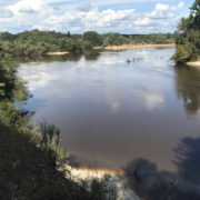
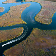
The Altamaha is a river of superlatives. Formed by the confluence of the Oconee and Ocmulgee Rivers, the Altamaha drains the third largest watershed on the eastern seaboard. With the Oconee’s headwaters stretching into the foothills of the Blue Ridge and the Ocmulgee’s into the heart of south Atlanta, the Altamaha drainage basin covers approximately 14,000 square miles, more than a quarter of the state. Because the Altamaha flows across the gently sloping Coastal Plain, it’s a poor candidate for dams. As a result, the Altamaha remains the longest free-flowing river system on the East Coast and also has the largest river discharge south of the Chesapeake Bay.
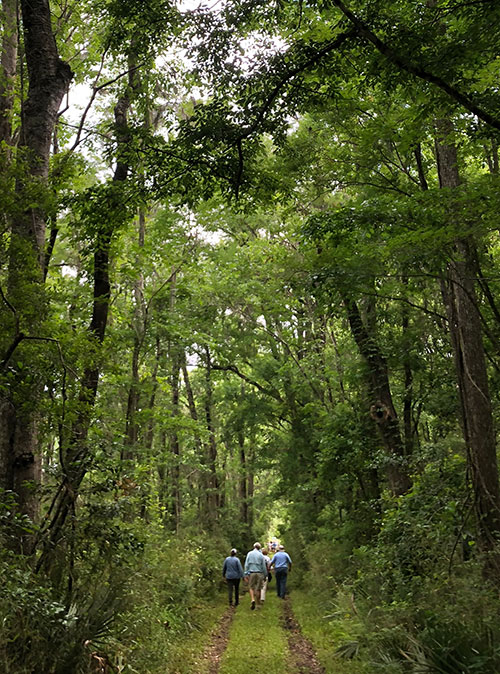
Altama by Jim Barger

Photo by Jim Barger

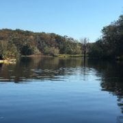
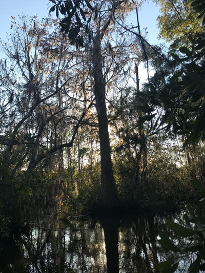
The Altamaha is far more than the water it carries. From the confluence to the sea, its 137-mile long valley features a great diversity of habitats: forested swamps and bottomlands, shaded bluffs, old-growth longleaf pines, isolated sand ridges, freshwater wetlands which are succeeded in turn by tidal marshes and barrier islands. It hosts 234 species of rare plants and animals — some found nowhere else on earth. The Altamaha system is such a unique complex of habitats that the Nature Conservancy named it one of the “Last Great Places on Earth.”

The Nature Conservancy’s Christi Lambert has championed protection of the Altamaha for over 25 years. “Because the watershed is so large, many people who live upstream may not even realize they are part of it. But the health of the Georgia coast depends on land and water use practices all the way downstream. The Altamaha feeds us, connects us, inspires us, and humbles us. Despite all that has happened in the ecosystems making up the Altamaha watershed, the river reminds us of the power of resilience. We have an opportunity and the responsibility to care for it today and into the future.”

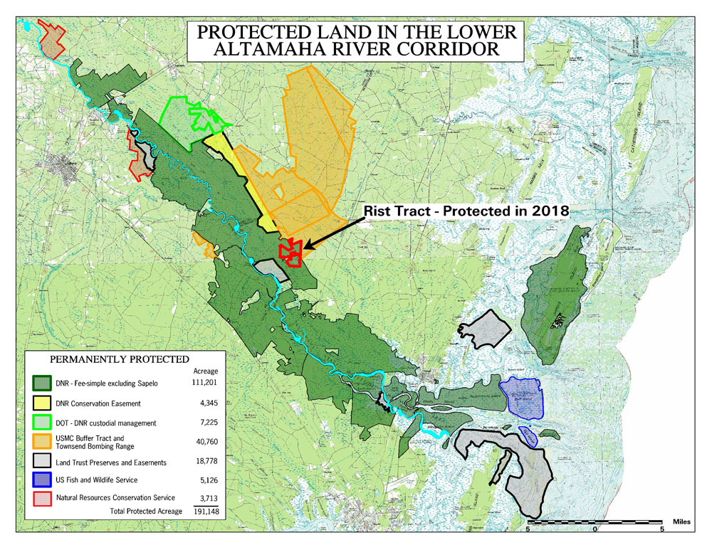
Recognizing the Altamaha’s unique attributes, federal and state agencies, non-profit conservation groups, businesses, industries, and private citizens have collaborated over decades to create a conservation corridor now protecting more than 180,000 acres on both sides of the river, from Jesup to the Atlantic. Private philanthropy has played a significant role in this work.

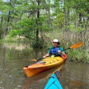
Jen Hilburn, the Altamaha Riverkeeper, has her own reasons for championing the Altamaha. “I was trained as an ornithologist. That work usually focused on one bird species or maybe a suite of species. Protecting the Altamaha at the ecosystem scale means we are not only conserving individual species but all the interconnections that make this river a hotspot for biodiversity. At the same time, I’m excited to see all the people enjoying the river, the families who are making memories for their children that will last a lifetime.  Through conservation, we are protecting our communities, our heritage, and our future.”

Much of this protected land is managed by the Georgia Department of Natural Resources. Steve Friedman, DNR’s Chief of Real Estate, attributes this success to the watershed’s high conservation value. “Everything comes together in the Altamaha,” says Friedman. “This is a story of the power of collaboration among stakeholders. We have incredible biodiversity plus a place that is important to a lot of people. Also most of these areas are accessible for public recreation in all its forms.  There is no way that we could have succeeded in protecting this corridor without partnerships and philanthropy.”

This burgeoning mosaic of public and private reserves not only is saving wild nature, it preserves Georgia’s cultural and ecological birthright for generations yet to come. Private landowners have been key in accelerating protection for the Altamaha. Newspaperman and Jesup native Dink Nesmith gave his own reason for protecting five miles of his family’s Altamaha River frontage and cypress forests under a conservation easement. “Foresters tell me that many of these trees predate the arrival of Christopher Columbus in the New World. A few may have been standing when Christ prayed in the Garden of Gethsemene. We are conserving and protecting a legacy for the great-great-great-grandchildren we will never know. If you won’t stand up for the people and places you love, who will?”

Top photo by Blake Gordon

Sansavilla Bluffs by Scott Coleman

The Conservation Fund: Conserving Land Along the Altamaha

By Dorinda Dallmeyer

Known for creating conservation solutions that “make environmental and economic sense,” The Conservation Fund is one of many partners collaborating on land conservation in the Altamaha watershed.  Andrew Schock, the Fund’s Georgia State Director, explains how the organization works in the Altamaha Corridor. “The Fund is able to provide a dedicated source of bridge capital that allows us to quickly acquire threatened forests with high conservation value. While we own, restore, and sustainably manage these lands as working forests, we work with our conservation partners to raise the funds to permanently protect them. When we relinquish control, the funds we receive are plowed back into conserving more tracts.”

“The Conservation Fund’s purchase of the Sansavilla Tract, a 20,000-acre parcel with 12 miles of Altamaha River frontage, is a great example of how we work,” observed Schock.  “It provided the state of Georgia breathing room to put in place a permanent conservation plan.  In the interim, we were able to harvest timber and begin restoring the native longleaf pine forest.

As with many of The Conservation Fund projects, private philanthropy played a critical role. Schock explains, “The Knobloch Family Foundation made a substantial early commitment providing some of the needed acquisition capital and The Robert W. Woodruff Foundation helped significantly at the end to close the gap as the property was being transferred to the State.  We were able to work with the State and other partners, like The Nature Conservancy, to leverage these private funds with grants from the U.S. Fish and Wildlife Service, the U.S. Forest Service ‘Forest Legacy’ program, state bond dollars, and funds from the Department of Defense.”

According to Schock, “Here in Georgia, and particularly along the Altamaha, we have a very collaborative and collegial land conservation community that works closely together. Coalition members may have differing motivations for being involved with conservation, and that’s fine. Regardless of the motivation, we’re working in common to achieve the same goal.”  Schock concluded, “Sansavilla is a wonderful success story.  Without the help of all our partners, the property would likely have been fragmented, leaving the habitat and watershed degraded, and public access for recreation eliminated.”

The Conservation Fund offers a variety of ways for donors to support conservation in Georgia and elsewhere. For more information, please see www.conservationfund.org.  For more about the Sansavilla Tract and the Gopher Tortoise Initiative of which it’s a part, see volumes 3 and 4 of Shoreline.

Photo by Scott Coleman

Water Trails by Altamaha RiverKeeper

Water Trails

By Dorinda Dallmeyer

If you want to experience the mighty Altamaha watershed firsthand, it’s now possible to paddle 443 miles on designated water trails from near the river’s headwaters east of Lithonia all the way to Darien. It’s not quite “from the summit to the sea” but a paddler can experience the journey that raindrops take from the Piedmont to the coastal marshes.

The Yellow River Water Trail runs for 55 miles south from Gwinnett County to Jackson Lake, where the confluence of the Yellow, South, and Alcovy Rivers that form the Ocmulgee has lain submerged since 1910. Below the dam, the Ocmulgee Water Trail extends for 250 miles to its confluence with the Oconee River just upstream from the Highway 351 bridge south of Uvalda.  Then the Altamaha Water Trail takes over for the final 137-miles jaunt to its delta.

It’s estimated that Georgia has more than one million paddlers who enjoy this form of home-grown ecotourism and the economic impact is significant.  According to the Georgia River Network, canoeing, kayaking, and rafting contribute $11.3 billion to Georgia economy annually. As a bonus, water trails often require lower implementation costs compared with other forms of economic development.

During the 2018 legislative session, the Georgia House of Representative unanimously passed a resolution voicing support for the Georgians who thus far have created more than 1000 miles of water trails statewide and encouraging the development of more opportunities for people to reconnect with Georgia’s rivers. And if that 443 miles leaves you wanting more, the Georgia Coast Saltwater Paddling Trail offers another 170 miles of paddling from the Savannah to the St. Mary’s.

For more information about Georgia’s water trails, please visit https://www.garivers.org/gwtc; for information about paddling the Altamaha River or providing philanthropic support to increase river access, contact Jen Hilburn at 912-441-3908 or jen@altamahariverkeeper.org. Jen serves as the Altamaha RiverKeeper.

Photo by Altamaha RiverKeeper

Marsha Certain

A Cardiologist with Her Heart in Coastal Georgia: Dr. Marsha Certain

By Dorinda Dallmeyer

Cherishing coastal Georgia comes naturally to Dr. Marsha Certain. The daughter of a physician, she grew up in Brunswick. After graduating from the Medical College of Georgia and completing a cardiology fellowship at Emory, her love of coastal Georgia beckoned her home. According to Dr. Certain, “I thrive in places where there’s not a lot of development. While my practice remains in Brunswick, I live on the bluff at Darien where I can see the Altamaha every day.”

Dr. Certain does more than admire the river from a distance. Her first kayak trip was on the Ocmulgee far upriver in the Altamaha watershed. That trip left her wanting more. She’s paddled the Oconee, the other main Altamaha tributary, as well as the dark, tea-colored waters of the Ohoopee near Reidsville. She reels off stretches of water she’s paddled on the Altamaha, relishing river names like “Alligator Congress” — those relics of the days of flatboats, steamboats, and timber rafts. From Darien she can launch on day trips up to Rifle Cut or to circumnavigate Champney Island on the Butler River. “I take any chance I can get to be on the river,” she says. “Fortunately my medical practice allows me to take turns both for work and play.”

She makes time for more than just work and play. As a Nature Conservancy board member, she is delighted with the role that TNC has played in the Altamaha watershed by protecting a river corridor now spanning 189,000 acres. And she is enthusiastic about expanding that protection, to extend as far headward as the South River inside Interstate 285 and to create a corridor to link with protected areas in southwest Georgia.

“We have a host of organizations focused on conservation in Georgia. There’s some overlap but each occupies a different niche. And they collaborate well.” She supports both the Altamaha Riverkeeper and the Satilla Riverkeeper, a river she praises for its own beauty. And on dry land, she’s involved with developing the Coastal Georgia Greenway, a project to create and connect cycling and multi-use trails in the coastal counties from the Florida border all the way to Savannah.

Marsha Certain

Photo by Scott Coleman

Dr. Certain is pleased by the passage of the Georgia Outdoor Stewardship Amendment (GOSA) in November’s election. “We’ve lagged behind other southeastern states in having a dedicated fund for conservation projects. GOSA will provide us with a reliable stream of conservation funds for the next ten years. It is incredibly important for all of Georgia.”

Her motivation for supporting conservation? Posterity. “Several years ago, I went with the Georgia Botanical Society to Lewis Creek. The trip leaders took us way into the interior of the island, to a cypress forest that was too remote to be logged. I was overwhelmed by the magnificence of these old-growth trees, the rich biodiversity surrounding us, and reminded of the resilience of the Altamaha watershed. I want to help protect this legacy for my grandchildren and all who follow them.”

Lead photo contributed by Marcia Certain

Coastal Conservation Project List 2.0 Released!

When meeting with people new to coastal conservation, we’re often asked, “How can we help?” To answer that question broadly and responsibly, Stewards has released the second edition of its Coastal Conservation Project List, a curated menu of high priority conservation projects with strong leadership and immediate needs for private philanthropy. Nominations were solicited from more than 20 trusted conservation professionals currently serving on the Georgia Coast.  Projects were selected based on Stewards’ working knowledge of coastal conservation priorities and confidence in the leadership and organizations involved.

Projects have been grouped in the following categories: Advocacy & Outreach; Land Conservation & Stewardship; Sustainable Development; Watershed Protection; and Wildlife Conservation. While most are highly collaborative, a single point of contact has been provided for each project for use when donors would like more information or want to make a donation.

We hope you will download the Project List and look for conservation projects for which your philanthropy can make a difference. If you choose to support a project from the list, please note your association with Stewards of the Georgia Coast as it will help us assess the value and impact of this effort.

Altama Office

Coastal Conservation Project List 2.0 – Featured Project: Altama Conservation Gateway – Master Site Plan

($2,500 committed/$27,500 needed)

In 2015, The Nature Conservancy acquired 4000 acres in the Altamaha watershed, strategically positioned where the river meets the salt marsh in Glynn County—the historic Altama tract. Today, the property is owned and managed by the Georgia Department of Natural Resources as the Altama Wildlife Management Area with The Nature Conservancy as a permanent resident. In addition to the extraordinary landscape, Altama is home to historic buildings and other structures. Given the location of the property and the opportunity these structures represent, TNC plans to explore a restoration of the facilities and the possibility of using the buildings for management purposes, research and to anchor a coastal conservation center to be known as the Altama Conservation Gateway.

Altama is strategically located to become a Gateway for the Coast and a Center for conservation, land management and coastal resources education in the region. A Master Site Plan for the property and core building area is needed to engage stakeholders and donors in the planning process. The planning process would include but not be limited to assembling and digitizing information on the property’s natural, historical and cultural features; artist renderings of the project; formation of an advisory committee to assess historical structures, landscaping, public use and conservation issues related to the transformation of the property; conceptualization of programs outside of traditional conservation such as historic preservation efforts, cultural and artistic uses of the center, and a collaboration with the region’s robust tourism industry; and, an economic analysis that considers the cost to bring the buildings to usable condition, ongoing maintenance expenses, and potential for revenue generation. For more information or to make a contribution, contact Christi Lambert at 912-617-0143 or clambert@tnc.org. Christi serves as the Director of Coastal and Marine Conservation for The Nature Conservancy in Georgia.

View the Coastal Conservation Project List.

Photo by Scott Coleman