Photo by Phillip Murdaco

Celebrating 50 Years of the Coastal Marshlands Protection Act

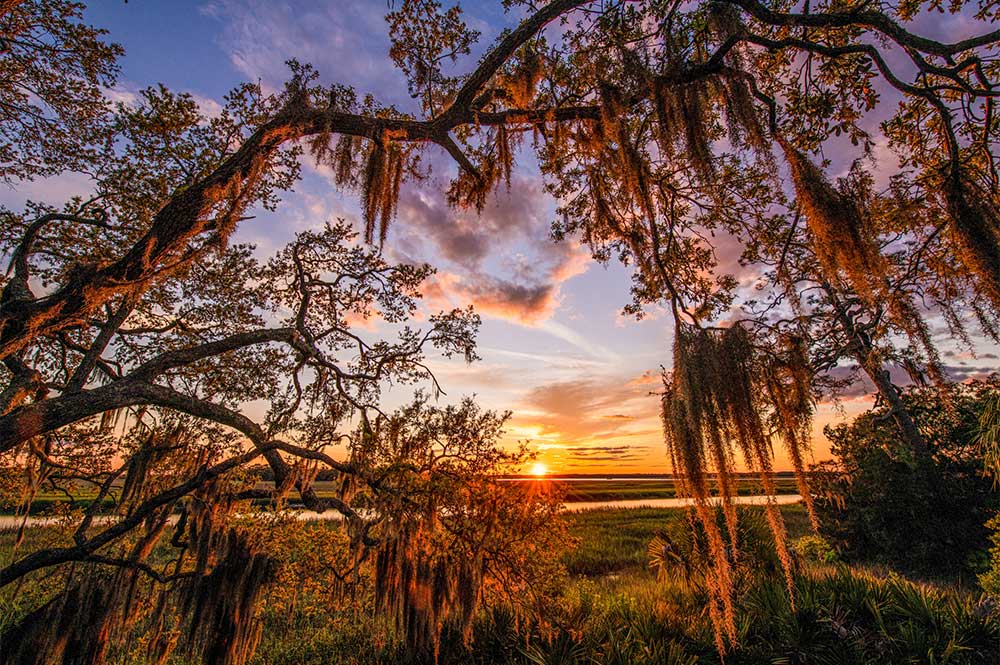
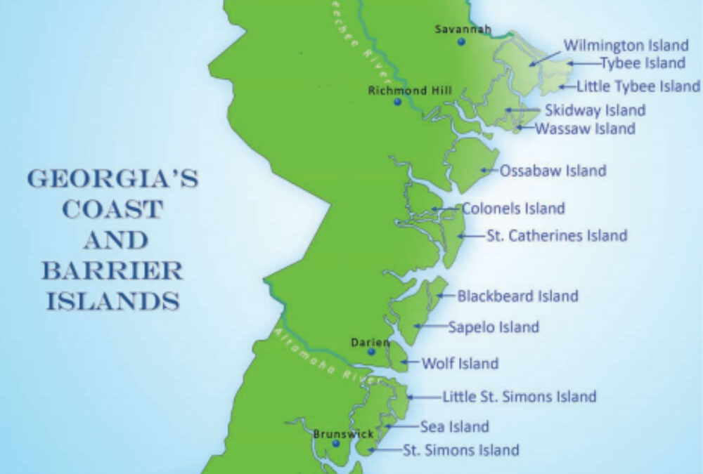
By Dorinda Dallmeyer

Fifty years ago, Georgians statewide fought hard to preserve our coastal landscape – a fight that centered just south of Tybee. There the coastal marshlands faced a novel, existential threat because of geology. During the 1960s, mining companies negotiated options to buy mineral rights on Little Tybee and Cabbage Islands. Their goal was to strip away the marsh sediments and extract extensive phosphate deposits that could be turned into fertilizer. The crisis intensified in early 1968 when the Kerr-McGee Corporation applied for a license from the Georgia Mineral Leasing Commission to mine phosphate from thousands of acres of the state-owned seabed offshore of Wassaw, Ossabaw, and St. Catherines Islands. Their plan called for dumping the mine waste atop neighboring barrier islands and marshland.

Kerr-McGee’s public relations campaign emphasized the putative economic benefits of the project. But the corporation failed to sway the Georgia public due to the efforts of a unique coalition of coastal scientists, students, conservation organizations, garden clubs, historical societies, hunting and fishing groups, and newspapers that rallied citizens statewide.

Remarkably, one figure in the fight was long deceased. Georgia poet Sidney Lanier (1842-1881) composed his famous work, “The Marshes of Glynn,” based on his observations of the marsh at Brunswick, Georgia from dawn to twilight. Combining descriptions of plants and animals of the marsh with the rhythms of the tidal cycle, the poem is deeply grounded in the spiritual impact Lanier felt before the majesty of God’s creation. Because generations of Georgia schoolchildren memorized the poem, people across the state were familiar with the coastal marshes even if they had never seen them for themselves. For them, mining Sidney Lanier’s marshes would be losing part of Georgia’s cultural heritage.

Others fought for the marshes based on their ecological value. The scientific studies of University of Georgia ecologist Eugene Odum and his colleagues at the Sapelo Island Marine Institute had established the importance of the coastal marsh functions, from primary productivity rivaling that of the rainforests to the marshland’s importance as a nursery grounds for fish and shellfish. To convey to the public that the marshlands were not just pestilential swamps, Odum borrowed a concept from the space race of the 1960s – the “life support system.” Just as astronauts could not survive in space without their life support systems, Dr. Odum argued that the marshes also provide a vast array of ecosystem goods and services vital to our life on Earth and to our coastal economies. To bring this message home, he and his graduate students barnstormed the state on an educational tour to explain the science behind why the marshes were more valuable in their natural state than destroyed for fertilizer production.

Another force supporting marsh protection were Georgia’s garden clubs. Mobilized by pioneer conservationist Jane Yarn, garden club members peppered the state legislature with thousands of letters opposing the destruction of Georgia’s coastal landscape. Newspapers across the state put mining the marshes on the front page and opposed it in their editorials. One editorial cartoon featured Sidney Lanier being scraped up by a bulldozer while penning the first lines of “The Marshes of Glynn.”

Representative Reid W. Harris guided the Coastal Marshlands Protection Act of 1970 to passage in the Georgia House and Senate

Representative Reid W. Harris guided the Coastal Marshlands Protection Act of 1970 to passage in the Georgia House and Senate

The full-throated public outcry from this massive coalition swayed the legislature and state agencies to not only deny Kerr-McGee’s license request but to move forward with comprehensive protection for Georgia’s salt marsh. The Coastal Marshlands Protection Act of 1970, based solidly on ecological science, placed the state in the role of trustee whose foremost duty is to serve the public interest in managing proposed activities in the marsh. In 1979, the state adopted the Shore Protection Act to control human activities within the sand-sharing system. It, too, was based on sound ecological and geological principles.

And the Coastlands Wait: How the Grassroots Battle to Save Georgia’s Marshlands Was Fought – and WonAccording to historian Chris Manganiello, the passage of these two acts represented the “gold standard” for environmental engagement. The fight to save the marshes created an organized environmental movement in Georgia which has multiplied and thrived in the intervening decades. The lessons learned fifty years ago continue to inspire a coastal conservation ethic that protects our natural heritage and seeks to meet the coming challenges of climate change impacts at our coast.

For a first person account of how the Coastal Marshlands Protection Act was pushed through the Georgia state legislature in 1970, we recommend Representative Reid Harris’s book, And the Coastlands Wait: How the Grassroots Battle to Save Georgia’s Marshlands Was Fought – and Won. It was republished this year by The University of Georgia Press with the philanthropic support of coastal conservation advocates.

Tybee Island History and Tourism

Tybee Island History and Tourism

By Dorinda Dallmeyer

People may believe that children should visit pristine, magnificent places like America’s national parks to develop a love of nature. On the contrary, many coastal conservationists recall fond memories of learning to love the Georgia coast by visiting the three Georgia barrier islands readily accessible by car. There they were able to dig to their heart’s content in sand. A run into the surf took care of any mess — so different from the red clay of home. There were gentle waves, a chance to spot dolphins surfacing beyond the swells, and maybe a ship or two on the horizon to set you dreaming.

Along with Jekyll and St. Simons, Tybee Island became the foundation of childhood memories for many. In Tybee’s case, its history of human visitation can be traced back over 4,500 years to early indigenous peoples who occupied this island along with neighboring Little Tybee and Wassaw. Here at the mouth of the Savannah River, these earliest Georgians feasted on its rich fisheries, leaving behind great shell rings as evidence of their success.

Although a variety of European colonial powers visited and claimed Tybee’s shores, the arrival of English settlers in 1733 had the decisive impact, for these people planned to remain. One of their earliest construction projects at Tybee was a 90-foot-tall wooden lighthouse built in 1736 to guide ships through shoals at the river’s mouth. Although storms and fires repeatedly destroyed a succession of wooden structures, by 1773 a 100-foot brick tower managed to survive until Confederate troops burned it to thwart its use by Union forces during the siege of Savannah. After the Civil War, the tower was rebuilt with an additional 94 feet of brick atop the remaining 60-foot base laid in 1773. Despite earthquake and hurricane, that’s the structure that still stands today. It’s one of the few 18th century lighthouses still operating in America, an enduring symbol of Tybee, and a drawing card for tourists. The lighthouse also lends its name to the phrase “from Rabun Gap to Tybee Light” which celebrates the geographic diversity of Georgia.

Tybee’s location at the mouth of the Savannah River meant that it underwent many changes due to navigation and flood control activities throughout the Savannah River watershed. Flood-control dams built far upstream in the river’s headwaters trapped sand that otherwise would have made its way downstream to Tybee’s beaches. As far back as the 1890s, dredging plus construction of long jetties along the Savannah River’s navigational channel also began to starve the sand supply to Tybee’s beaches. One set of anthropogenic changes begat another. Since 1882, there have been more than forty Federal engineering projects to stabilize and renourish Tybee’s beaches to protect homes and businesses and to provide ample dry beach area for recreational needs – an effort that continues today.

1901 brochure, courtesy of the Special Collections Library, University of Georgia

1901 brochure, courtesy of the Special Collections Library, University of Georgia

Organized tourism dates back to 1870, when the “Tybee Improvement Company” began to formulate plans to develop the island as a beach resort. Part of the island’s draw was the opportunity to escape the bustle of Savannah; another was the emergence of the belief that salt air was healthy and rejuvenating. In 1873, small steam packet boats began to make daily runs to Tybee, and by 1876 there was a spacious hotel for overnight guests as well as a horse-drawn streetcar line from the boat pier down Tybee’s “main drag.” More restaurants and accommodations followed, along with beach-side pavilions for dancing or simply taking in the scenery.

People of that period were just as interested in speed of movement as we are today. To transport more visitors to the island more quickly than a multi-hour steamboat trip, construction started on the Savannah and Tybee Railway in 1886. Anyone who has ever ventured into the marsh understands that it would be no easy feat to lay a structurally sound roadbed across such soft ground cut by tidal creeks. Despite many challenges, the railbed was completed in late 1887. By 1890, the railroad had been purchased by the precursor of the Central of Georgia Railway, a major passenger and freight railroad serving Georgia and parts of Alabama and Tennessee.

The Central of Georgia took its new acquisition to heart. It printed color brochures featuring Tybee as a prime destination. Elaborate timetables and fare schedules showed Georgians all over the state exactly how long it would take to get there and ticket costs, including discounts for multi-day visits. It was an easy transfer from the main Savannah railroad station to the Tybee depot on Randolph Street, where passengers knew the Atlantic awaited after chugging across 18 miles of marsh. Going by rail instead of by boat cut that travel time in half. In 1910, the railroad carried over 160,000 people from Savannah to Tybee; a roundtrip ticket cost 40 cents (about 26 dollars today, adjusting for inflation).

postcards courtesy of the authorLike their predecessors, the railroad constructed hotels, restaurants, and attractions for all these tourists. Other entrepreneurs built their own cottages, boarding houses, and pavilions to accommodate the throngs enjoying the beach. And there were plenty of them, like my great-grandmother Bessie Andrews Haddock with her daughter Elizabeth who memorialized their visit in this photo postcard, dressed in their finest and posed in front of a painted ship on a painted ocean.

Not surprisingly, the rise of the personal automobile spelled the end of the railroad. In 1923, what we know today as U.S. 80 opened to parallel the railroad. No longer would visitors have to accommodate a train schedule or brush off cinders from the steam engine once they arrived. Supplanted by the automobile, rail service ended in 1933. Although it no longer will take you all the way to Tybee, approximately six miles of the old railbed now are the McQueen’s Island Trail, providing pedestrians and cyclists the opportunity to enjoy the salt air and sea breeze at a slower pace.

Tybee continues its growth, both as “Savannah’s beach” and as a magnet for visitors around the country. Recent figures estimate that Tybee draws more than a million visitors annually. Thanks to the work and generosity of conservation philanthropists, a new facility will open in Spring 2021 for Tybee Island visitors and residents alike: The Tybee Island Marine Science Center. The 5,000 square foot new center is located on Tybee’s North Beach and features views of the Atlantic Ocean and the Calibogue Sound at the Savannah River Entrance. It has the capacity to reach over 100,000 people annually, connecting them to the stewardship of Georgia’s coast through hands-on education and conservation programs. Fundraising efforts to complete the exhibits are still underway. Here are details on how to support the project.

Neighboring islands offer a different kind of coastal experience. Little Tybee Island is a favorite place to explore by kayak and for overnight camping. Comprised of 6505 acres of undeveloped salt marshes and tidal creeks and 3.5 miles of beach, Little Tybee is accessible only by boat. It is owned and managed by the state of Georgia, with a conservation easement retained by The Nature Conservancy. Wassaw National Wildlife Refuge preserves a snapshot of Georgia’s original coast, reminiscent of what those first “tourists” would have seen thousands of years ago. Its timber was never cut nor was the island put to the plow. As part of the Savannah Coastal Refuges system, Wassaw also is accessible only by boat. It is open from sunrise to sunset for low-impact activities such as hiking, picknicking, and birdwatching.

In addition to all those humans, Tybee, Little Tybee, and Wassaw host a wide variety of bird life, visitors and residents alike. In the fall of 2018, the Western Hemisphere Shorebird Reserve Network designated much of the Georgia coast as a Landscape of Hemispheric Importance, including portions of Tybee as well as the Wassaw National Wildlife Refuge. The designation recognizes the Georgia coast’s importance to migratory birds, who winter here or refuel and rest on round-trip journeys that may span from the Arctic to Tierra del Fuego.

Like all of Georgia’s islands connected to the mainland by causeways, Tybee faces challenges from balancing tourism with its year-round residents’ quality of life, managing growth to avoid the destruction of its environmental amenities which bring people there in the first place, and adapting to the inexorable rise of sea level. The decisions made today will ensure that Tybee’s sandy beaches continue to inspire generations yet to come.

Provided by The Caretta Research Project

Wassaw Island, The Caretta Research Project, and a 150+ Year Family Legacy of Philanthropy

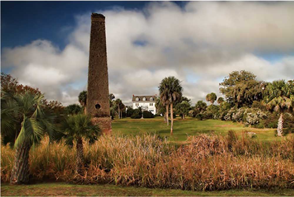
By Christa Hayes

George Parsons, born in 1826 and raised in Maine, worked with his brother to build successful business ventures in southern cities, including Savannah.  Parsons was known for his strong family ties, a concern for community needs, and generosity.  Parsons established a culture of giving in his family that would be handed down through the generations and it’s left an indelible mark on Wassaw Island and continues to impact sea turtle conservation work taking place there today.

Parsons purchased Wassaw Island in 1866 as a gift for his bride, Sarah Eddy Parsons.  He went on to build a housing compound for his family and friends at the center of the island.  As the Parsons, their children, and their children’s children spent time on Wassaw Island, they developed a deep love for it and an appreciation for the island’s special character.  In 1930, with an eye toward the future, family members and others formed the Wassaw Island Trust to preserve Wassaw in its natural state.

In the 1960’s, trustees became concerned that the state of Georgia might condemn the island and open it for development or public use (Georgia had purchased Jekyll Island under a condemnation order in 1947). In response, they made arrangements to convey Wassaw to the United States for permanent preservation as a National Wildlife Refuge.  To facilitate the transaction, the Nature Conservancy of Georgia bought Wassaw Island from the Trust for $1 million in 1969 and, in turn, sold it to the federal government for the same amount. The transaction carried three stipulations.  First, the island would remain in its natural state.  Second, no bridge could be built connecting the island to the mainland.  And, finally, the Wassaw Island Trust would retain 180 acres for on-going use, including the housing compound. Not surprisingly, Parsons family trustees would soon use their influence to make the island accessible and the property available for philanthropic and conservation purposes.

More than 150 years after George Parsons first cultivated within his family both a culture of giving and a love of the Georgia coast, his descendants continue that tradition by supporting sea turtle conservation with their time, personal commitment, and financial support.

In the early 1970s, volunteer herpetologists and the Savannah Science Museum launched a conservation effort focused on loggerhead sea turtles (Caretta caretta) out of a concern for the declining population.  A Parsons family member provided crucial support to the initiative, including transporting researchers and volunteers to Wassaw and providing housing.  This led to the 1972 founding of the Caretta Research Project. It was one of the first sea turtle conservation initiatives in the country and it continues today.  Caretta’s on-going mission includes monitoring and protecting loggerhead sea turtle nests on Wassaw and educating the public about sea turtle conservation. Their efforts are successful with the continued support of private philanthropists. Their current needs include funding to purchase basic research supplies, including tags and applicators, as well as a new Kawasaki Mule. More details are available on the Coastal Conservation Project List.

Provided by the City of Darien

Collaborative Efforts Underway to Preserve Butler Island

By Burch Barger

Hosted by The Coalition to Save Butler Island and organized by One Hundred Miles, three consecutive gatherings (both in person and online) were held recently to facilitate public conversation about the future of Butler Island. Participants in these sessions, titled “Creating a Future for Our Past,” included community members, descendants of enslaved people, conservationists, historians, tourism professionals, theologians, private foundations, academics, elected officials, state agency representatives, and more.

Butler Island, located in McIntosh County and part of the 30,000-acre Altamaha Wildlife Management Area, is an important and historic landmark from our coast’s history. It is the site where Pierce Butler enslaved more than 500 people and where famed actress and abolitionist Fannie Kemble documented the atrocities that she witnessed there in her influential work, Journal of a Residence on a Georgia Plantation, 1838-1839.  Kemble’s journals were seminal in turning the tide of Great Britain’s public opinion against slavery.  Plagued by gambling debts, Butler became notorious for the largest single auction of enslaved people in U.S. history known as the “Weeping Time,” where hundreds of Butler Island families were separated and taken to Savannah and held captive in horse stalls before being sold and shipped off to enslavers throughout the antebellum South.

Visited and widely used by thousands of people since it became a wildlife management area, Butler Island has struggled greatly to meet maintenance demands. Upkeep of the complex system of dikes that create vital habitat for waterfowl is costly.  Structures on the island, particularly the postbellum Huston House, have fallen into disrepair but at present remain viable for restoration. Built in 1927 by the former owner of the New York Yankees who personally recruited Babe Ruth, the Huston House was a duck hunting lodge that hosted not only Ruth himself but also other baseball luminaries like Lou Gehrig and Ty Cobb.

The future of Butler Island currently hangs in the balance. Georgia House Bill 906, which was designed to allow the transfer of Georgia heritage preserves to private developers, met with strong public resistance and was defeated earlier this year. In the wake of this legislative battle, The Coalition to Save Butler Island seeks to devise solutions for not only financing the upkeep of Butler Island but also honoring those enslaved on the property and protecting the site’s historic and natural assets for generations to come.

Recommendations and comments from the public sessions have been gathered and shared with the Georgia DNR, owner of Butler Island. Based on resounding feedback from session participants, the Coalition is creating a “Friends of Butler Island” organization and applying for 501c3 status, as well as pursuing funding for projects that will help with restoration and other initiatives on the property. It will take continued collaboration and creative fundraising efforts to generate the revenue necessary to preserve Butler Island. To support this important movement which seeks to promote both environmental conservation and cultural preservation, please contact Megan Desrosiers, CEO of One Hundred Miles.

Provided by One Hundred Miles

Five Coastal Waterways Named to Georgia Water Coalition’s 2020 “Dirty Dozen” List

By Burch Barger

Published in November 2020, the tenth edition of the Georgia Water Coalition’s “Dirty Dozen” list highlights the issues that threaten twelve waterways throughout the state. Five of these are located in our coastal region: the Altamaha River, the Satilla River, the St. Simons Sound, the Okefenokee Swamp, and Cumberland and Little Cumberland islands. Below is a brief synopsis of each threat and information on the conservation groups working to protect these vital waterways.

Altamaha River: The discharge from Rayonier Advanced Materials chemical pulp mill in Jesup has landed the Altamaha River on Georgia’s “Dirty Dozen” list more times than any other waterway. Altamaha Riverkeeper is advocating for Rayonier to upgrade its wastewater treatment standards as it seeks a renewal of its pollution control permit.

Satilla River: A proposed 463-acre landfill project located two miles from the river in Brantley County raises concerns ranging from pollution of groundwater and surface water to the risk of increased flooding. Satilla Riverkeeper notes the proposed landfill “is in a very vulnerable area, surrounded by a rural community that sources its drinking water from groundwater wells. Proper site limitations are essential to protecting the Satilla River, its tributaries, wetlands, and groundwater resources from contamination and pollution. The proposed site is not appropriate for a solid waste handling facility.”

St. Simons Sound: After more than a year of preparations and delays, the cutting and salvage process has begun on the Golden Ray, the 656-foot cargo ship capsized in the St. Simons Sound. As the massive boat is cut into eight sections, its cargo of 4000 cars and tens of thousands of gallons of oil threaten to contaminate the sound, surrounding marshes, beaches and fisheries on St. Simons and Jekyll islands. Altamaha Riverkeeper is monitoring the salvage process and recommends that NOAA conduct a Natural Resources Damage Assessment of St. Simons Sound, determining the environmental impacts and identifying restoration projects to compensate for losses associated with the disaster.

Okefenokee Swamp: Changes to the Clean Water Act went into effect earlier this year, removing from federal protection 376 acres of wetlands located within Twin Pines Materials’ proposed 12,000-acre titanium mining site near the Okefenokee Swamp. “A federal hurdle removed, if Twin Pines can now secure necessary state permits, mining operations can commence.” Conservation groups working to organize citizens and to inform Governor Kemp about the importance of protecting the Okefenokee include One Hundred Miles, Suwannee Riverkeeper, and Georgia River Network.

Cumberland and Little Cumberland Islands: A proposed rocket launching facility, Spaceport Camden, would sit on the banks of Todd Creek, an important tributary to the Satilla River located four miles from the shores of Cumberland and Little Cumberland Islands. The small launch missions proposed for the Spaceport Camden site have averaged a 43% failure rate between 2009 and 2016.  This puts the human and wildlife populations — as well the natural wonders — of Cumberland Island and Little Cumberland Island at heightened risk of fire, pollution, and loss of life. One Hundred Miles continues to track this proposal and to express grave concerns for the impacts it would have on the Georgia coast.

Photo by Megan Desrosiers

Stewards’ 2020 Field Events: Recreation and Respite in Our Coastal Surroundings

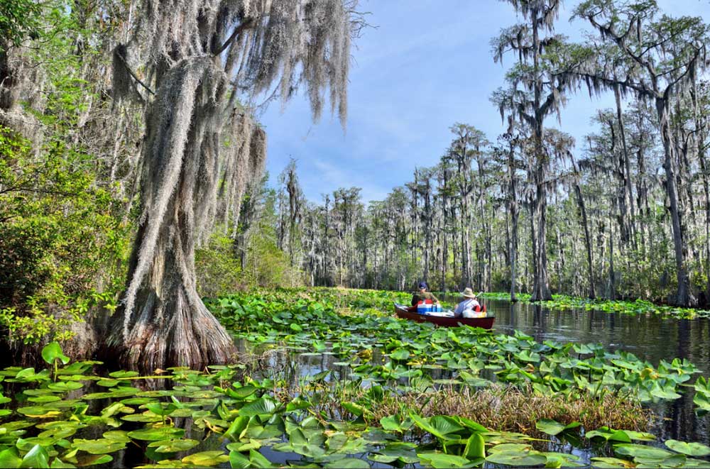
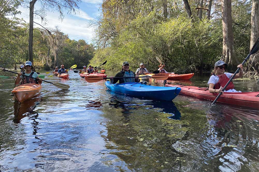
By Burch Barger

Undoubtedly, 2020 has been a challenging year for in-person engagement in all sectors of our society.  Meeting via Zoom just isn’t the same as chatting in person.  Thankfully, our coast’s mild climate and wide array of outdoor offerings have allowed Stewards to find a few creative, safe ways to gather for learning and recreation this year.  As many in our Stewards network have noted, the opportunity to immerse ourselves in nature has been a welcome respite from virtual meetings and pandemic headlines.

In June, we gathered for a Stewards paddle trip along the upper reaches of Cathead Creek through historic rice canals, cypress swamps, and manatee foraging grounds.  Native plant sightings along our path included buttonbrush trees and false dragonhead, among others. Christi Lambert, Director of Coastal and Marine Conservation for The Nature Conservancy in Georgia, led our conversations about past and current conservation projects within Georgia’s mightiest river system, the Altamaha.

June 2020 Cathead Creek Paddle Trip

June 2020 Cathead Creek Paddle Trip

In September, we celebrated World Shorebirds Day with a Stewards boat trip to the mouth of the Altamaha River. Abby Sterling, shorebird biologist with Manomet’s Georgia Bight Shorebird Conservation Initiative, led our conversations about fall shorebird migration, the importance of our coast for shorebirds, and current conservation initiatives involving shorebirds in Georgia.

Traveling at high tide, we saw congregations of roosting shorebirds on the northern tip of Little St. Simons Island, at Little Egg Island Bar, and on Wolf Island. Our group’s sightings included American Avocets, Marbled Godwits, American Oystercatchers, and Long-billed Curlews, among others.

September 2020 Shorebirding Boat Trip

September 2020 Shorebirding Boat Trip

September 2020 Shorebirding Boat Trip

September 2020 Shorebirding Boat Trip

In November, we kayaked coastal Georgia’s only designated Wild and Scenic River, Ebenezer Creek. While paddling through a maze of 1,000+ year-old dwarfed bald cypress trees, we learned from renowned coastal naturalist Stacia Hendricks about the area’s unique natural and cultural histories. Megan Desrosiers shared updates on One Hundred Miles’ work with community members and elected officials to ensure the history and ecology of Ebenezer Creek are protected forever.

Following the paddle trip, we gathered for a picnic lunch near the 18th century Jerusalem Lutheran Church at New Ebenezer.  Afterwards, the Georgia Salzburger Society provided a brief tour of the church and museum.

Left to Right: November 2020 Picnic and Tour of Jerusalem Lutheran Church; November 2020 Ebenezer Creek Paddle.

We are planning a full slate of Stewards excursions for 2021, and we hope you will make plans to join us.  On Friday, January 22nd, we will kick off the new year with a hike in Cannon’s Point Preserve guided by Wendy Paulson and leaders from the St. Simons Land Trust.  Stay tuned for emails about the January 22nd trip and others to follow in 2021.