Sansavilla Conserved!

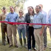
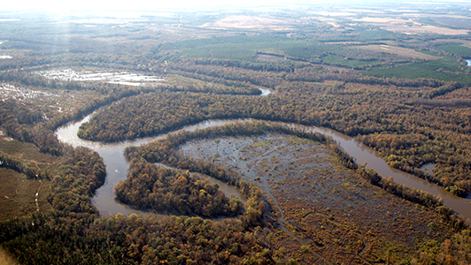
Protection of the lower Altamaha River began in 1968, piece by piece.  The pace accelerated in the last twelve years as federal and state agencies collaborated with non-profits and private philanthropy, investing more than $90 million to underwrite conservation easements and outright purchases.  The “missing piece,” a 19,500 acre property known as Sansavilla featuring 12 miles of Altamaha River frontage, is finally secure. A host of partners made it possible using a phased approach: The Conservation Fund, The Nature Conservancy of Georgia, Georgia Department of Natural Resources, U.S. Fish & Wildlife Service, U.S. Forest Service, and the Department of Defense.  Private philanthropy played a critical role with leadership from the Robert W. Woodruff Foundation and the Knobloch Family Foundation. A ribbon cutting was held on October 16 to mark the closing of the final phase.

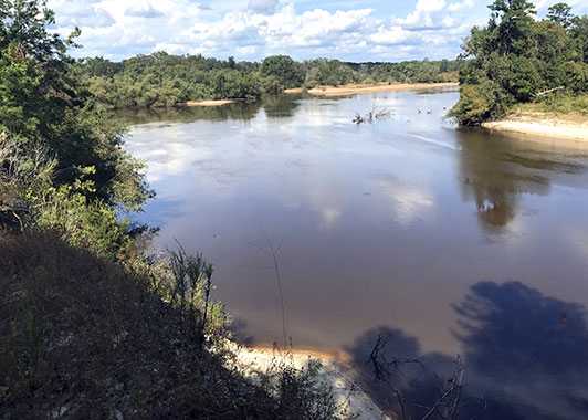
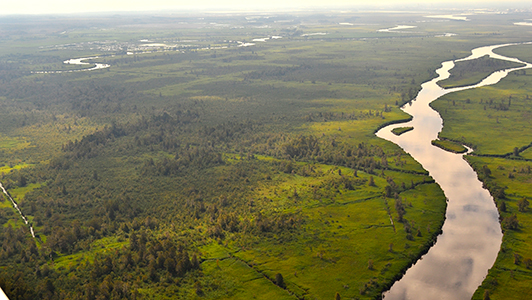
First as a footpath and then as a ferry landing, for centuries Sansavilla Bluff has been a waypoint for people crossing the immense Altamaha River floodplain. Now the Bluff serves as the linchpin in a decades-long effort to safeguard and restore the lower Altamaha.

At Sansavilla, slash and loblolly “pines in lines” are being cut or thinned to restore the once-dominant longleaf pine forest and its understory plants. With prescribed burns every few years to control competing vegetation, the rich plant diversity will support greater numbers of a wide variety of wildlife, including the gopher tortoise.

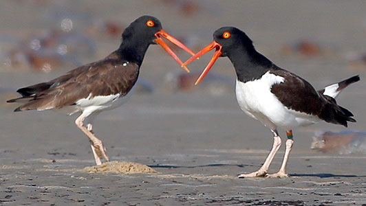
As a keystone species — one whose presence in the landscape enables other plants and animals to thrive — tortoises excavating burrows for their own living quarters draw as many as 350 species of animal “tenants,” from tiny mites to indigo snakes and burrowing owls. As testimony that Sansavilla is prime tortoise habitat, 400 tortoises already make their home there. Now the tract also will serve as a refuge for tortoises relocated from construction and mining sites elsewhere within their range. Ultimately, conservation biologists expect up to 1000 residents when restoration is complete.

While few of us will live to see the longleaf seedlings at Sansavilla Bluff reach their old-growth majesty, conservation success stories are happening right before our eyes along the Altamaha. A unique collaboration focused on conserving and restoring this historic landscape will benefit generations of Georgians yet to come.

For more information about the Gopher Tortoise Initiative and the crucial role tortoises play in the native longleaf pine and sandhill ecosystems, please see “The Gopher Tortoise: A Catalyst for Conservation,” in the previous issue of Shoreline.

Ribbon cutting photo by Lance Cpl. Moreno; Sansavilla Bluff photo by Scott Coleman.

Georgia Barrier Islands Named a Landscape of Hemispheric Importance

While few Georgians may realize how critical our coastal zone is to birds throughout the Western Hemisphere, the birds know.

On November 1, the Western Hemisphere Shorebird Reserve (WHSRN) announced the designation of a wide swath of Georgia’s barrier islands and marshes as a “Landscape of Hemispheric  Importance.” As the 100th site recognized for its importance to shorebird migration, it is only the third designated at the “landscape” scale. This new WHSRN Landscape comprises 79,709 acres of critical habitat including beaches and dunes, offshore sand bars, extensive sand and mud flats exposed at low tide, as well as salt marsh on the lee side of the barrier islands.

This Landscape supports 35 species of shorebirds during some part or all of their migratory cycle. To understand its importance, look at a few numbers. The Georgia Barrier Islands WHSRN Landscape supports more than 30% of the biogeographic population of rufa Red Knot, with approximately 23,400 of these birds resting and refueling during their southbound migration and 17,775 on the northbound return. The Landscape also supports large numbers of overwintering birds such as the Great Lakes breeding population of the Piping Plover, along with American Oystercatcher, Short-billed Dowitcher, and Black-bellied Plover. Attracted by the abundance of fiddler crabs, one of the largest gatherings of Whimbrel in North America assembles here to fatten up before departing for breeding grounds around Hudson Bay and in the high Arctic of the United States and Canada.

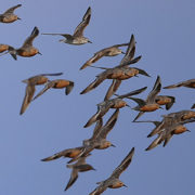
Georgia’s barrier islands are owned and managed by a diverse group of private and public entities, many of which have committed to the WHSRN designation. The Georgia Shorebird Alliance (GSA), a collaborative group of biologists, land managers, and organizations devoted to the protection of Georgia’s shorebirds, submitted the nomination. Commitment to the nomination comes from GSA members, including the National Parks Service (Cumberland Island National Seashore, Fort Pulaski National Monument), U.S. Fish and Wildlife Service (Savannah Coastal Refuges Complex), and the privately-owned Little Cumberland Island, St. Catherine’s Island, Little St. Simons Island, and the Cannon’s Point Preserve and Musgrove Preserve on St. Simons Island. The Landscape of Hemispheric Importance also includes the Altamaha River Delta, previously designated in 1999 by WHSRN as a Site of Regional Importance.

Many of us cherish the opportunity to stroll Georgia beaches alongside flocks of small shorebirds, watching the “peeps” as they diligently patrol the swash zone for food. For more details about how these shorebirds stitch our coast into a web of vital connections stretching from the Arctic to Tierra del Fuego, please see https://www.whsrn.org/georgia-barrier-100th

Photos by Brad Winn.

Savannah River Cutoff Restoration Task Force: Can We Un-Straighten a River?

Fat Meat Point, Saucy Boy Point, High-Low-Jack-and-the-Game Point, Spanish Cut, Wildcat Cut, Devils Elbow, Royal Lake — names leap from old navigation charts tracing the Savannah River as it winds from Augusta to the Port of Savannah. But following a century of dredging to straighten the river, many names have been forgotten. Now a study is underway to gauge the feasibility of restoring water quality and wildlife by making the river wind once more.

Like other Coastal Plain rivers, the Savannah meanders, carving sweeping curves across its wide floodplain. In transporting Georgia commodities from the Piedmont to the sea, boatmen navigating these curves — the “points” — gave them their sometimes colorful names. With time, as a meander loops more tightly, the river erodes a shortcut across its neck — think “Wildcat Cut” — separating the meander from the river’s main flow. The meander then begins to silt in. Now connected to the river only during floods, a marooned meander transforms into an “oxbow” lake.

In an effort to keep the Savannah River competitive as a means for commercial transportation, the U.S. Army Corps of Engineers regularly dredged its channels from the late 1800s until the completion of the New Savannah Bluff Lock and Dam in 1937.  Dredging resumed from 1959 to 1976 and, in the process, the Corps cut through the necks of thirty-two meanders to shorten the distance from Augusta to Savannah by twenty-six miles. Ultimately, barge traffic couldn’t compete with cheaper, faster rail and truck transport and by the late 1970s, the Corps stopped maintaining this section of the river.

Unfortunately, channelization’s impacts remain. Consider that the longer distance a river flows, the cleaner it becomes. Meanders slow down the water to allow more time for good bacteria to clean it.  During floods, the river reconnects with oxbow lakes, those lost wetlands that help break down and assimilate toxins.  In short, an artificially straightened river impairs water quality.

The Savannah River’s water quality has been especially challenged by post-war population growth and industrial development in the Savannah Valley. The river now receives waste discharges from forty-eight industrial sites and municipalities along one hundred-mile stretch, ranking it third on the list for toxic loads in Georgia rivers. Poor water quality affects fish and other aquatic organisms, increases water treatment costs for industry and cities, and impairs the public’s ability to enjoy a wide variety of recreation on the river.

Elsewhere in the United States, restoration of natural meanders has provided substantial benefits to river corridors: cleaner, better oxygenated water; additional flood protection, improvement of fisheries and wildlife habitat; and new recreational and economic benefits.

Why not the Savannah?

A $3 million feasibility study slated for completion in 2019 should give us the answer. The Savannah River Cutoff Restoration Task Force includes federal and state agencies from Georgia and South Carolina, local municipalities like City of Augusta Utilities, the Georgia Ports Authority, non-governmental organizations, and for-profit businesses. The Savannah Riverkeeper and the Phinizy Center for Water Sciences serve as the non-federal sponsors for what Riverkeeper Tonya Bonitatibus calls “a project of historic proportion: the potential restoration of 23 meanders.”

Half of the $3 million cost for the study comes from mitigation funds related to the Savannah Harbor Expansion Project. But the feasibility study partners must raise the matching funds from non-federal sources. This presents a wonderful opportunity for conservation donors.  If you are interested in underwriting their work toward restoring this historic landscape, where place-names might no longer be only memories on a map, contact Tonya Bonitatibus at info@savannahriverkeeper.org

Photo by Savannah RiverKeeper; Illustration by Grabau, A Textbook of Geology, 1920.

Savannah River Clean Water Fund: Conserving Land for Clean Water

Floating along the Savannah River’s forested banks, you probably aren’t thinking “Wow, what a great water treatment facility!”

Maybe you should.

Nearly two-thirds of America’s clean water supply comes from stream flow cycled through forests. These natural systems filter runoff and break down contaminants, producing high-quality water to support human and industrial uses. And there’s economic value in this “green infrastructure” — it operates 24/7 and runs on sunshine. Shouldn’t we conserve these free ecosystem services and the land that provides them?

The vision for protecting the Lower Savannah watershed for the sake of long-term water quality goes back to 2009 when a group including conservation organizations, landowners, forestry companies, government agencies, and water utilities began exploring the idea.  With confidence in the premise, the Savannah River Clean Water Fund (SRCWF) was established in 2016 to coordinate the initiative.

According to Braye Boardman, SRCWF’s Executive Director, “If you ask people what the economic drivers are for Augusta and Savannah, they will list nearly everything but the river itself. We needed to change that. With approximately 75 percent forest cover here in the Savannah Valley, clean water costs our utilities about $40 million per million gallons to produce (based on data from a national study).  Without forest cover, these costs would nearly quadruple. Projections for accelerated population growth and industrial development along this river tell us we don’t have the luxury of taking thirty years to conserve our watershed like New York City did with the Hudson. Ultimately, communities around the world with an abundant, clean water supply will be the economic winners.”

The value proposition for water utilities is clear:  conserving land now and promoting better land management practices is less expensive that building water treatment capacity down the road.  So far, five water utilities have pledged a total of $1.133 million per year for three years toward land conservation, better land management practices, and science and research in the Savannah River valley.  In addition, municipal water utilities are key members of the SRCWF’s management and advisory structure along with state and federal agencies, land trusts, environmental NGOs, and philanthropic foundations. Boardman observed, ” Utilities around the country are beginning to look at investments in green infrastructure as part of their multi-tier strategy to provide quality drinking water to their customers.  But this is the first time water municipalities in two states, covering a 2.8 million acre watershed, have pooled resources together to protect their source-water and ensure a sustainable supply of clean water for generations to come. When utilities invest in clean water, they know they are investing in something important to their taxpayers and water users, especially if they can accomplish it in a more cost-effective manner,” according to Boardman.

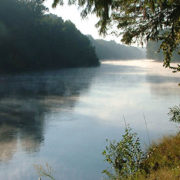
Using maps generated by The Nature Conservancy, SRCWF has targeted 210,000 acres in the watershed as critical priorities for maintaining water quality, with a goal of protecting 8,000 acres annually.  The estimated cost over the life of the project is $52 million.  Unlike South Carolina, Georgia has no state conservation fund providing financial incentives for landowners to place their land under conservation easements or otherwise enhance protection for these critical acres.  As such, donors will play a critical role.

The project offers a compelling opportunity for conservation philanthropy. With core support from water utilities, SRCWF is committed to seeking annual matching funds to support land acquisition, conservation easements, deed restrictions, responsible land stewardship and land management practices, as well as education and scientific research related to water quality.  “We need to make the strongest pitch possible to landowners and to other funders that this is not just about conserving a landscape, wildlife, and the outdoors but also generating a real return on investment in the form of clean water — something that none of us can do without,” says Boardman. “By underwriting land conservation, we also can maintain and create family-supporting jobs in forestry and agriculture.”

For more information about SRCWF, please contact Braye Boardman at 706-530-5962.  Until SRCWF’s website is completed, a temporary site can be found at http://www.usendowment.org/ntmsrcwf.html.

Photos by Savannah RiverKeeper.

Rick Richards, Jr.: River Steward

“Small towns are generally smack in the middle of nature,” observed Dr. John W. “Rick” Richards, Jr., “and my hometown of Kershaw, South Carolina, was no different. I spent most of my summers, and much of the shoulder seasons at Lake Wateree down stream from the Catawba River:  catfishing, frog gigging, skiing, and swimming. When I was 15, my parents decided to build a cabin at the lake and challenged me to design and build it. They bought a ski boat and told me that if I recruited friends to help and we worked from 8am-6pm, my friends and I could ski from 11am-2pm.  My parents saved on labor, bought many, many gallons of gas, and my friends and I spent a lot of time at the lake over the next three years building the ‘River Cabin,’ which is unchanged and still being used today – 50 years later.”

Having grown up on the lakes and rivers of northern Georgia and South Carolina, it’s no wonder that Rick feels a close connection to the region’s waters and uses his philanthropy to protect them.

Throughout Rick’s life he’s always sought out water – as an undergraduate, a medical student, during his posting at Ft. Gordon while in the Army, and later when settled in Augusta as a faculty member at the Medical College of Georgia. The Richards family spent a lot of time at Lake Thurmond and by 2005 had decided to move there. After several months searching for lake property, they found land offering a sweeping vista of the Savannah River and the Sumter National Forest beyond.

The water quality on Rick’s section of the Savannah is very good. “The river temperature is a bit chilly for a lot of watersports but fishing and boating go on year-round,” says Rick. “One issue that I have become aware of is the need for better enforcement of erosion control laws. Due to uncontrolled runoff from new developments, even those well away from the shoreline, a portion of the Savannah became clogged with silt very quickly. We need to protect the river for all its users, wildlife included.”

After teaching at MCG for seven years, Rick began a new phase of his life as a “serial entrepreneur” in fields including health promotion and disease prevention, health data management, medical consulting, and cost containment. His business successes inspire his philanthropy.

One environmental group supported by Rick’s philanthropy is the Savannah Riverkeeper (SRK). Riverkeepers generally work at the grassroots level to protect everyone’s right to clean water.  They do this by focusing on the health and well-being of a specific watershed and the communities it supports. As the primary guardian of the Savannah River, SRK’s challenge is significant.  The organization works to protect a river system that spans nearly 400 miles with stakeholders in two states.  All of Georgia’s six Riverkeepers are part of the Waterkeeper Alliance, founded in 1999 by Robert Kennedy and a group of fishermen who set out to clean up the Hudson River in New York.  The movement took off, and now there are over 300 Waterkeeper organizations worldwide.

Rick’s connection to SRK began when he saw the news that burglars had stolen all of the organization’s computers during a break-in. “I was in the process of replacing my work computers so I took equipment to the Riverkeeper office and helped them get back to protecting the river again.” In addition to his financial support, members of Rick’s Boy Scout Troop have partnered with the SRK on a number of Eagle Scout Leadership Projects.  The Scouts of Troop 643 (Evans, GA) erected information kiosks at boat/kayak/canoe access points on the river, installed fishing line recycling bins at boat landings, cleaned and placed trash receptacles in access areas, cleaned the shoreline of Lake Olmstead, built an outdoor classroom at Phinizy Swamp and even painted and landscaped the SRK office building.

“The people who are employed by environmental groups could choose to work where they would earn a lot more money; yet, this is their calling. They make a financial sacrifice to do great things — what I call ‘God’s work.’” Rick continued, “I want this community to thrive and so do they. When they need additional funds and/or labor to accomplish what we all are trying to achieve, all I have done is offer a bit of help.”

Rick Richards shares his lifelong love of rivers with his family and his community. “The closer I can get to water, the more appealing it is to me. Walking along the river or simply sitting and watching it roll by has such a calming influence. It connects one with the world beyond….”