Willow Passage

Georgia’s Coastal Watersheds, Part II: The Ogeechee

By Dorinda Dallmeyer

High in the Georgia Piedmont south of Union Point and Siloam, springs rise in two pastures to form the Ogeechee. Unlike most of Georgia’s rivers, whose headwaters are composed of creeks and streams bearing their own names, the Ogeechee is the Ogeechee all 250 miles from its springs to the sea.

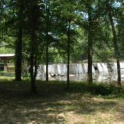
The Ogeechee is one of the few Georgia rivers not held back by high dams to create major impoundments for hydropower and recreation.  But Piedmont settlers knew how to put the river to work. Where small waterfalls interrupted the river’s flow, enterprising locals constructed low mill dams to harness energy for everything from grinding corn to weaving fabric.

Dorinda Willows
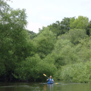
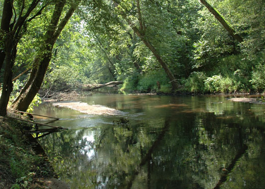
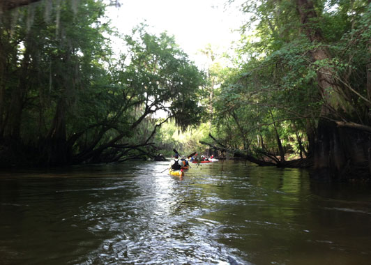
Below the Fall Line, the Ogeechee begins its meandering path to the Atlantic. Its slow-moving “black” waters offer plenty of opportunities for fishing and boating. But where the river bends, the Ogeechee narrows and trees crowd its banks. Willows grow so thickly on both banks of the river that a paddler may realize for the first time that willow leaves have a lovely fragrance. On the other hand, powerful currents carving the meanders undercut the bordering trees. Eventually they fall, clogging downstream passage with “strainers” that require either a portage around the obstacle or a saw to cut through it.

The wide floodplain of the lower Ogeechee is studded with thick stands of cypress. Along the riverbanks grow Ogeechee tupelos, first described by William Bartram in 1765. In flower these trees supply rich nectar for honeybees to process into tupelo honey. The fruit — the so-called Ogeechee “lime” — offers a tangy juice eaten right off the tree or when made into jelly. The cypress and tupelos also provide a stronghold for one of the south’s most elegant birds, swallowtail kites.

According to Ogeechee Riverkeeper Simona Perry, “Despite the impression of a largely rural landscape, this region of Georgia is experiencing increased development pressure from population growth, water withdrawals, and wastewater discharges as well as from climatic changes leading to sea level rise. These pressures are causing dramatic changes in water quality and quantity and threaten serious ecological decline.” But Perry is undaunted. “Ogeechee Riverkeeper continues to stand alongside local communities in this fight to ensure that our children have clean waterways, abundant wildlife and fisheries, and healthy communities for at least seven more generations.”

Ogeechee Shoals at Fall LineOne of the largest landholders on the lower Ogeechee is the U.S. Army’s Ft. Stewart. Covering 274,000 acres, it is the largest military installation east of the Mississippi. In addition to protecting 14 miles along the river’s south bank, the base also encompasses a large portion of the Canoochee River watershed, the Ogeechee’s only major tributary. Working alongside state and federal agencies as well as private conservation groups such as the Ogeechee Riverkeeper and the Nature Conservancy, Ft. Stewart supports and manages populations of more than 20 state and/or federally-protected species. Some endangered or threatened species on the base include the red-cockaded woodpecker, the eastern indigo snake, the flatwoods salamander, the wood stork, and the shortnose sturgeon.

Very few people speeding south along I-95 probably glance west to notice the confluence of the Canoochee with the Ogeechee. Here the river widens and slows as the tide makes its presence felt. The river begins extravagant loops among the rectilinear remnants of rice field dikes, rice culture that once made coastal Georgia a world leader in exports. Flanked by saltmarsh, the Ogeechee finally meets the Atlantic between Wassaw Island National Wildlife Refuge and the Ossabaw Island Wildlife Management Area, protected at its very end as those waters from high in the Piedmont finally meet the sea.

The Ogeechee Storykeeper Project: Building Community for a River Less Travelled

By Dorinda G. Dallmeyer

Since the arrival of Paleo-Indians around 11,500 years ago, the Ogeechee watershed has been indispensable to its people. The late Jack Leigh knew the river was not just carving a path to the sea when he said,  “Water shapes our lives, and we are shaped by water.”

In 1984, it was Leigh who introduced the Ogeechee River to a world beyond its watershed in his book “The Ogeechee: A River and Its People” (University of Georgia Press). The book combined Leigh’s evocative photographs of the river and its people alongside stories gathered during two years in which he traced the length of the river. These stories revealed to Leigh that,  “The Ogeechee River is and always has been a sacred place, rooted in the hearts of its people.”

Since the 1980s, however, census figures reveal dramatic population shifts in the watershed. Some of Georgia’s fastest growing counties now span the Ogeechee tidewater, while many rural counties upstream are losing more people than they are gaining. How do the hearts of today’s people value the Ogeechee in the 21st century?

Thanks to a new project, recent arrivals and residents of long standing have another opportunity to speak about what the Ogeechee means to them. Building on Leigh’s legacy, the Ogeechee Riverkeeper and Georgia Southern University are working together to identify, collect, and share these stories. The Ogeechee Storykeeper Project seeks to ensure that the river’s unique cultures, histories, and ecosystems are documented and archived in a way that honors previous generations and helps to cultivate a new sense of community throughout the watershed.

According to Riverkeeper Simona Perry, “By connecting people along the river’s length through the power of story, we aim to strengthen community ownership and stewardship of the entire Ogeechee watershed.  Our project is a meaningful way for sharing knowledge and fostering understanding between present and future generations.”

For more information about the Ogeechee Storykeeper Project or to make a donation, contact Simona Perry at 866-942-6222, extension 1, or simona@ogeecheeriverkeeper.org.

Southern Forest

U.S. Army at Ft. Stewart and the Georgia-Alabama Land Trust

By Dorinda Dallmeyer

If asked what conservation philanthropy looks like, a common response would be monetary contributions or volunteer hours. But the U.S. Army at Ft. Stewart and the Georgia-Alabama Land Trust have another way to protect important habitat along the Ogeechee River — conservation easements with private landowners.

Coastal Georgia is one of the fastest growing regions in the state. Rising property values and rising ad valorem taxes often encourage landowners to sell or to convert timberland and agricultural land into residential or commercial property. Ft. Stewart is a major economic force in the Richmond Hill/Hinesville area and intends to remain a good neighbor. Its military forces need the flexibility to train when and where they want within the confines of Ft. Stewart. Additionally, all of the longleaf pine acreage within the base must be managed with prescribed burns on a three-year rotation. Encroaching development could mean that buffers to shield residents from noise, smoke, and other forms of disturbance have to lie inside Ft. Stewart’s boundary, effectively reducing the total area and time available for training. As a result, siting of schools and high-density residential and commercial development immediately adjacent to the base is potentially incompatible with Ft. Stewart’s training and military readiness mission.

To provide incentives for adjoining property owners to keep their land in its relatively undeveloped state, the Army created the Army Compatible Use Buffer (ACUB) program. This program identifies priority areas for preservation around the base perimeter. In partnership with the Army at Ft. Stewart, the Georgia-Alabama Land Trust (GALT) works with owners to encourage them to place land under conservation easements.

According to program director Hal Robinson “Development is forever, so protection needs to be forever, too. Conservation easements are a flexible, tailored way to protect land in perpetuity. A required annual inspection by the easement holder (in this case GALT) ensures that the terms of the agreement are implemented faithfully. Because each property is unique, we work closely with private citizens and timber companies as well as public landowners like county governments to identify the conservation attributes of each parcel under consideration.”

Complementing Ft. Stewart’s protection of fourteen miles of the Ogeechee’s south bank are conservation easements protecting four miles of river frontage on its north bank. One two-mile stretch was a private donation while the other was an easement entered into by Chatham County for its Blue Sky Preserve. Hal Robinson notes “In addition to conserving habitat, these riverside easements preserve the vista for boaters to enjoy on this stretch of the Ogeechee.”

“From a landowner’s perspective, conservation easements provide a unique mechanism for individuals to protect the land they love. While we identify high-value habitat like floodplains and bottomland hardwoods that should be protected, we also recognize that a landowner may wish to continue to use the uplands as they have in the past,” said Robinson. “Conservation easements permit a limited number of home sites on the parcel as well as forestry and/or agriculture consistent with best management practices. That way, property can continue to pay for itself. ”

Historically, conserving land required a private landowner to relinquish certain valuable property rights while society benefited at little or no cost. After all, a tax deduction benefits only those landowners who have taxable income. ACUB adds an alternative incentive. Rather than donating an easement to gain a tax deduction, a landowner can choose to sell development rights (i.e., a conservation easement) to GALT, thereby contributing to a compatible use buffer. Once an appraisal is obtained and the parties agree on the price to be paid, the landowner receives a lump-sum payment and GALT holds the easement in perpetuity. Combining the donated and sold easements, GALT protects approximately 37,000 acres through the ACUB program with a donated component value of $7,000,000 over just the last five years.

Both Ft. Stewart and Ft. Benning partner with the Georgia-Alabama Land Trust in implementing the ACUB program. If you own land near Ft. Stewart and would like to help preserve military readiness and protect valuable conservation values while continuing to conserve the pristine natural beauty of your land, please contact Hal Robinson at hrobinson@galandtrust.org or (912) 508-1855; also see www.georgiaalabamalandtrust.org.