Photo by Megan Desrosiers

Stewards’ 2020 Field Events: Recreation and Respite in Our Coastal Surroundings

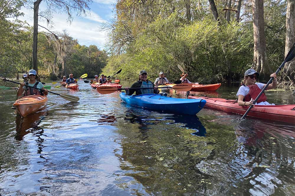
By Burch Barger

Undoubtedly, 2020 has been a challenging year for in-person engagement in all sectors of our society.  Meeting via Zoom just isn’t the same as chatting in person.  Thankfully, our coast’s mild climate and wide array of outdoor offerings have allowed Stewards to find a few creative, safe ways to gather for learning and recreation this year.  As many in our Stewards network have noted, the opportunity to immerse ourselves in nature has been a welcome respite from virtual meetings and pandemic headlines.

In June, we gathered for a Stewards paddle trip along the upper reaches of Cathead Creek through historic rice canals, cypress swamps, and manatee foraging grounds.  Native plant sightings along our path included buttonbrush trees and false dragonhead, among others. Christi Lambert, Director of Coastal and Marine Conservation for The Nature Conservancy in Georgia, led our conversations about past and current conservation projects within Georgia’s mightiest river system, the Altamaha.

June 2020 Cathead Creek Paddle Trip

June 2020 Cathead Creek Paddle Trip

In September, we celebrated World Shorebirds Day with a Stewards boat trip to the mouth of the Altamaha River. Abby Sterling, shorebird biologist with Manomet’s Georgia Bight Shorebird Conservation Initiative, led our conversations about fall shorebird migration, the importance of our coast for shorebirds, and current conservation initiatives involving shorebirds in Georgia.

Traveling at high tide, we saw congregations of roosting shorebirds on the northern tip of Little St. Simons Island, at Little Egg Island Bar, and on Wolf Island. Our group’s sightings included American Avocets, Marbled Godwits, American Oystercatchers, and Long-billed Curlews, among others.

September 2020 Shorebirding Boat Trip

September 2020 Shorebirding Boat Trip

September 2020 Shorebirding Boat Trip

September 2020 Shorebirding Boat Trip

In November, we kayaked coastal Georgia’s only designated Wild and Scenic River, Ebenezer Creek. While paddling through a maze of 1,000+ year-old dwarfed bald cypress trees, we learned from renowned coastal naturalist Stacia Hendricks about the area’s unique natural and cultural histories. Megan Desrosiers shared updates on One Hundred Miles’ work with community members and elected officials to ensure the history and ecology of Ebenezer Creek are protected forever.

Following the paddle trip, we gathered for a picnic lunch near the 18th century Jerusalem Lutheran Church at New Ebenezer.  Afterwards, the Georgia Salzburger Society provided a brief tour of the church and museum.

Left to Right: November 2020 Picnic and Tour of Jerusalem Lutheran Church; November 2020 Ebenezer Creek Paddle.

We are planning a full slate of Stewards excursions for 2021, and we hope you will make plans to join us.  On Friday, January 22nd, we will kick off the new year with a hike in Cannon’s Point Preserve guided by Wendy Paulson and leaders from the St. Simons Land Trust.  Stay tuned for emails about the January 22nd trip and others to follow in 2021.

Georgia’s Coastal Watersheds, Part V: The St. Marys River

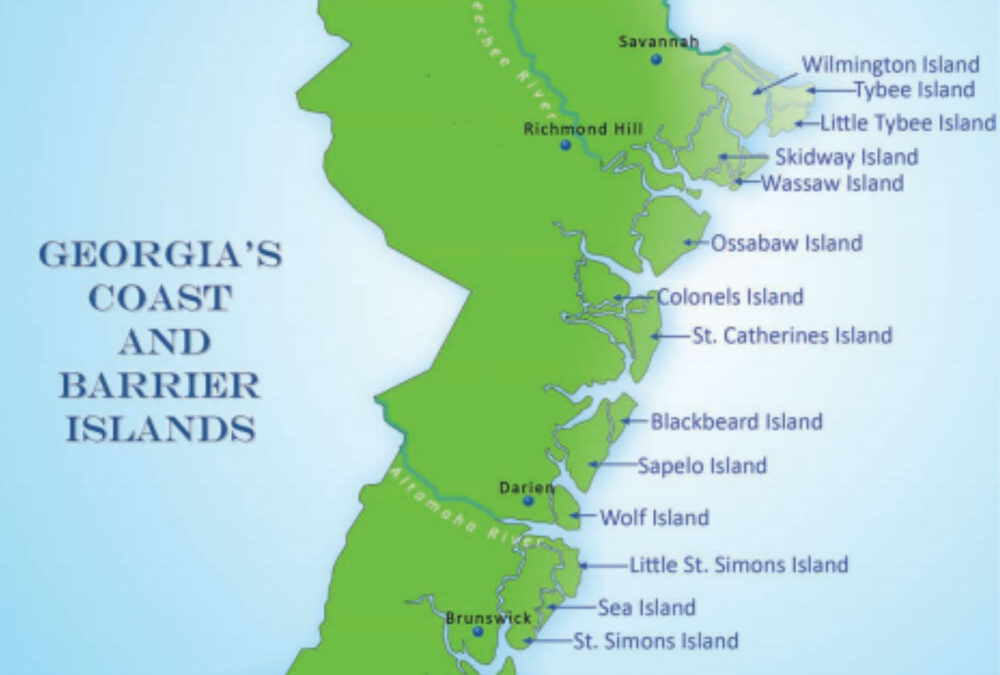
By Dorinda Dallmeyer

Looking at a map of Georgia, you see its boundaries marked by straight lines and sinuous river valleys. The most striking is our southern boundary with Florida, where a line arrows east-southeast to meet Georgia’s Big Bend – the 126-mile-long St. Marys River.

In 1800, it took the skills of Andrew Ellicott, a noted surveyor of the early American Republic, to mark the Georgia-Florida line. The west end was easy – the confluence of the Flint River with the Chattahoochee. But the eastern end was something entirely different – described as “the headwaters of the St. Marys River.”  The St. Marys rises in the Okefenokee Swamp, 700 square miles of wildness and myth that has come down to us today as a mixture of “the land of trembling earth,” the movie “Swamp Water,” and the antics of the swamp animals in the beloved Pogo comic strip. But it was a real-life problem for Ellicott. To run that line to its eastern terminus, he had to determine where swamp ended and river began.

To avoid clashes with the Seminoles who were increasingly hostile to surveying parties dividing the land between the United States and Spain, Ellicott sent most of his men eastward on foot to the riverside settlement of St. Marys. Ellicott sailed with the rest of his party and the instruments on a schooner around Florida to rendezvous with them there. Then the mapping task began, not on foot but by canoe upriver. If you have crossed the Okefenokee on a multi-day paddle, it’s a wonderful outing in wild nature. Ellicott’s paddle was strictly business. He and his men paddled back and forth, into and out of the swamp, until Ellicott was satisfied that he had located the St. Marys headwaters – where swamp became river. The survey party marked the site with a mound of soil which came to be known as “Ellicott’s Mound.” Now supplemented with an official federal benchmark, Ellicott’s Mound can even be located on Google Maps simply by entering its name.

Boundaries – natural and artificial – continue to influence management of the St. Marys watershed. Along its length, the river is bordered by two Georgia counties – Camden and Charlton – and two Florida counties – Nassau and Baker. Because they border both on the Atlantic and the more navigable sections of the St. Marys, Nassau and Camden historically have had higher population densities, which have only increased with the advent of coastal tourism and development. Charlton and Baker have remained more sparsely populated, although each is facing a growing need to implement smart planning and sustainable development.

According to Anna Laws, St. Marys Riverkeeper, a key to managing the watershed holistically is the St. Marys River Management Committee, composed of representatives from all four county commissions, their technical staff, private citizens, and entities like the Riverkeeper. All the counties are focused on improving water quality in the watershed. According to Laws, “These counties have porous soil and a shallow water table, especially in periods of heavy rainfall. So throughout the watershed, all the counties are grappling with high fecal coliform counts and nutrient inflow into the river. Traditionally, the more sparsely populated rural counties have relied on septic tanks for sewage treatment. In the past, homes along the river tended to be concentrated in fishing communities or privately-owned cabins used sporadically on weekends and vacations. Now more people are buying these sites and converting them for use as single-family, year-round homes.  If tanks are not pumped out on a three to five-year interval, the older septic systems simply can’t keep up with the demand on them.”

One innovative approach by Camden County and the Riverkeeper was obtaining grant funding to cover the cost of pumping out or replacing old septic systems bordering Horsepen Creek, a St. Marys tributary. The drop in fecal coliform counts was immediate and long-lasting.

An additional role that the Riverkeeper has taken on is water-quality monitoring throughout the watershed. “Our efforts are focused on supplementing the states’ monitoring programs. We are developing a baseline data-set both to look for monthly trends and, especially, to identify ‘hotspots’ in need of timely action. We have trained high school students and their teachers to conduct water quality monitoring tests so that they become our eyes on the watershed.”

Whether at the coast or inland, all four counties face the potential for explosive population growth, particularly because of the St. Marys’ proximity to northward sprawl from Jacksonville and Duval County. However, the needs of the counties are different. According to Laws, “Nassau and Camden Counties are densely developed and now must grapple with the results of past laissez-faire growth which has produced congestion and over-taxed wastewater treatment facilities. As counties in the immediate coastal zone, they also now are more focused on flood planning, either due to hurricane impacts or long-term sea-level rise. At a different stage of development, Charlton and Baker would welcome growth, as long as it’s smart growth and not at the expense of losing natural amenities or in repeating the mistakes made elsewhere.”

But desires for smart growth could be overwhelmed by powerful economic interests. Like many rural counties around the South, Charlton County is grappling with disposal of coal-ash waste from power plants. Despite the toxic heavy-metal content of coal ash, Georgia currently regulates coal-ash waste disposal no more stringently than it does household garbage. South of Folkston, the Chesser Island Road Landfill continues to receive ash not only from Georgia but also from a plant in Puerto Rico. That ash arrives via bulk-cargo ships which dock near Jacksonville and offload the ash into dump-trucks for transport to the landfill – a site less than five miles east of the Okefenokee Wildlife Refuge.

An additional threat to the Okefenokee, the St. Marys, and potentially the water supply for the whole region is the proposed expansion of surface mining. According to Laws, “Mining heavy minerals concentrated in the sands of ancient beach ridges has been carried out for many years at a relatively small scale in the region. However, this new proposal envisions an extremely large mine site close to the Okefenokee with unknown impacts to the hydrology of the swamp and the St. Marys, our invaluable groundwater supply, and impacts on endangered and threatened species.” Currently the U.S. Army Corps of Engineers is considering whether or not the proposal requires an environmental impact statement before its approval.

The St. Marys ties Camden County’s coast to the wild places it shares with Charlton County. For many years, the Okefenokee has been a tourist destination, not just to see alligators and cypress but to also for visitors to envision what the earliest people arriving there might have seen in 3,500 B.C.E.  To help build the sustainable growth of ecotourism in the region, the St. Marys Riverkeeper is in the process of working with the counties to improve access to the river by developing riverside parks and installing more boat ramps and canoe/kayak launch sites.

According to Laws, “Between Folkston and Moniac, which is close to the headwaters, there are not many places to get onto the St. Marys and enjoy what its blackwaters and riparian forests have to offer.  We’re currently working with Georgia River Network to expand access to paddling north of Folkston, the traditional head of navigation for traders plying the river.”

And so, maybe soon you will be able to re-enact Ellicott’s decision 220 years ago on where to draw the line — where a swamp becomes a river.

St. Marys Riverkeeper has two conservation projects underway that need philanthropic support. The first is the outreach program to educate homeowners along the watershed on best septic system maintenance practices. The second is the expansion of the water quality monitoring program to include not only bacterial tracking but also the collection of chemical and macroinvertebrate data. To support these efforts, contact Anna Laws at anna@stmarysriverkeeper.org.

Wildlife and Recreation on the St. Marys River

By Burch Barger

From its cypress and bottomland hardwood swamps to its salt marshes and mud flats, the St. Marys Basin provides habitat for a diversity and abundance of animals and plants. There is a large diversity of native tree species found in the basin, including bald cypress, several species of pine, sweetgum and tupelo gum, southern and sweetbay magnolia, red maple, several species of holly, tulip poplar, Carolina willow, river birch, and a variety of oaks. Wildlife in this area includes white-tailed deer, river otters, beavers, raccoons, alligators, gopher tortoises, wild turkeys and ribbon snakes. The middle portion of the river supports black bears, bobcats and the red-cockaded woodpecker.

The St. Marys River offers many opportunities for recreation and sightseeing. Canoeing, boating, fishing, and camping are just some of the ways to enjoy the river. The upper reaches of the St. Marys – the north and middle prongs – are narrow, twisting streams with good current and beautiful cypress and tupelo trees. After the two prongs meet, the river becomes wider and is characterized by bluffs, swamps and snow-white sandbars. Development along the banks is scattered and infrequent and campsites are plentiful. Popular sportfish include redbreast sunfish, bluegill, largemouth bass and various catfish.

If you are looking for a nice spot to start a kayak trip on the St. Marys — or perhaps just a scenic picnic locale — Riverkeeper Anna Laws shares, “Traders Recreation Area in Folkston is located near the Okefenokee Swamp and has a campground. For advanced paddlers, this section of river is lovely!” Once a fort and settlement, Traders Hill today is a 32-acre recreation park on the banks of the St. Marys River where visitors can launch a boat, camp, fish, swim, or enjoy the natural beauty of the river.

Coastal Conservation in a Pandemic—Manomet: Finding Solace in Nature

By Abby Sterling

With all of the uncertainty caused by the global pandemic, there is a tremendous amount of solace to be found in nature. As Manomet’s shorebird biologist for the Georgia Bight Shorebird Conservation Initiative, I am being kept busy with our nesting shorebirds, like American Oystercatchers and Wilson’s Plovers, and our migrating shorebirds that are heading up to the Arctic, like Red Knots and Dunlin. Ever an optimist, I look for silver linings in every situation. While this crisis highlights many challenges for all of us in the non-profit world, there have been some interesting opportunities as well.

I’ve been working on a project with partners from National Fish and Wildlife Foundation (NFWF), National Audubon and Virginia Tech to better understand how both birds and people use our publicly accessible beaches. This March, while the beaches were closed for two weeks, I was able to continue monitoring. And while that short window wasn’t enough time to see a true shift in how the birds were using the beaches, we did see Wilson’s Plovers starting to explore sites where we had not observed them nesting before. Tybee Island, normally so busy with people, had hundreds of Tree Swallows roosting on the empty beach. During one survey, I saw three Black-necked Stilts at the surf, a long-legged black and white shorebird that is typically found in quiet beach ponds or impoundments. And at another site, just last week, a Wilson’s Plover nest hatched all three eggs, and now fuzzy chicks are zipping around on a beach that is still closed to the public.

We’ve also been so lucky that we are able to work with our partners to continue to prioritize data collection and management, while carefully following local ordinances and health guidelines. We were able to install symbolic fencing at Gould’s Inlet on St. Simons Island to protect nesting Wilson’s Plovers and Least Terns, many volunteers are still collecting International Shorebird Surveys, and we are coordinating an evening count of Whimbrels this week. Every evening at sunset, Whimbrels leave the marshes where they feast on fiddler crabs and fly to remote sandbars to roost for the evening where they can be safe from disturbance and predators. It is an incredible spectacle that lasts through May, until the well-fed Whimbrels fly to the Arctic to nest. The Whimbrel count is part of a project supported by NFWF to determine what sites could serve as long-term counting locations to help us better monitor the populations of this declining species.

At Manomet, we’ve been working hard to fill in the gaps that were generated by cancelled events and talks to connect with people digitally. Some of you may have tuned in for our Whimbrel webinar, which can be accessed here, and we hope to have more of these offerings in the future. We are working hard to continue building strong connections within our communities to address some of the most pressing challenges that shorebirds face in our region. We are using this time to continue planning programs to reduce recreational disturbance, build partnerships to support habitat protection and conservation, and raise awareness for the fragile resources that exist within the Georgia Bight. To support our efforts, please click here, and specify in the comment space that you’d like your gift to be designated for Georgia’s shorebirds.

We thank you for your interest, and we look forward to the next time we can all be together safely!

Coastal Conservation in a Pandemic—One Hundred Miles: Prioritizing Advocacy and Education

By Burch Barger

With the Georgia legislature suspended due to the Coronavirus pandemic and local volunteers and donors sheltering in place, the rhythm and location of Megan Desrosiers’ work as President and CEO of One Hundred Miles has changed.  But the mission has not. Megan and her staff remain committed to protecting our coast – “no matter when, no matter what” – and the necessary work of coastal conservation, in the forms of both advocacy and education, continues in the midst of this uncertain time.

On the state level, bills addressing coal ash, flood risk reduction projects, and land use restrictions in the Satilla River watershed are all still alive in the General Assembly. During this temporary hiatus, Megan and her staff continue to work at the grassroots level to ensure these issues remain priorities when the session reconvenes.  On the local level, One Hundred Miles continues to advocate against the proposed Spaceport in Camden County, to advocate for responsible revisions to the rural zoning ordinance in Glynn County, to push for cleanup of superfund sites in Glynn County, and to protect the Okefenokee Swamp from proposed nearby mining.

For coastal stewards who are eager to brush up on their ecological education and/or to connect with fellow conservationists while still sheltering at home, One Hundred Miles offers a variety of online programming. There are three weekly programs for digital nature education, including Nature in Your Neighborhood, Family Nature Friday, and Animals, Authors and Art. One Hundred Miles also facilitates an environmental book club that meets online and organizes advocacy workshops that are conducted virtually. For more information, visit their Facebook page.

One Hundred Miles is not immune to the economic impacts of Coronavirus. After taking difficult measures to reduce overhead costs and to stretch donor dollars to the farthest extent possible, Megan remains positive. She believes that, with the continued generosity of conservation donors, One Hundred Miles will be better and stronger in the long run.  To support the ongoing advocacy and education work of One Hundred Miles and to ensure the long term viability of this important organization, visit their website or call Megan Desrosiers at (912) 223-8608.

Coastal Conservation in a Pandemic—The Orianne Society: Making Adaptations and Seizing Opportunities

By Burch Barger

Chris Jenkins, CEO of The Orianne Society, acknowledges that these are challenging times for conservation nonprofits.  After making adaptations to keep staff safe from the Coronavirus pandemic and reducing their budget for the fiscal year, The Orianne Society remains committed to its mission: conservation of reptiles, amphibians, and the ecosystems they inhabit.

What does Orianne’s work look like in these uncertain times? Staff travel is restricted, outreach events are cancelled, volunteer efforts are postponed. Funding for new staff positions and some seasonal technicians has been cut. In the interest of staff safety, they have reduced the size of field crews and developed policies for disinfecting gear and maintaining hygiene in the field.  The bright side: most of Orianne’s work is conducted in wild places which, by definition, accommodate social distancing.  The work continues, and the commitment to the mission remains.

Orianne’s coastal work most affected by the pandemic is gopher tortoise and Eastern indigo snake habitat restoration. They have a team of land managers (Mopani Strike Team) who work inland year-round implementing prescribed fire and restoring native grasses. The team has continued its work, but where and how widely they burn has been impacted by concerns of smoke and respiratory issues. Plans to add a second strike team in 2020 — focused on Georgia’s coastal counties and muhly grass habitats on barrier islands – are dependent upon donor funding. Chris remains hopeful that our Stewards of the Georgia Coast network can help. To make a gift supporting Orianne Society’s efforts, you can visit their website or contact Chris Jenkins by phone at (208) 241-9124.

Chris notes that the pandemic, though it has presented multiple challenges, also has offered opportunity.  It has led the Orianne Society staff to produce more internet-based education and outreach material and to recognize the power of online communications for promoting conservation. We are the beneficiaries of their efforts, as we now can gain an insider’s view of the gopher tortoise, the Eastern spadefoot frog, Dante the Gila monster, and much more with a simple click of our mouse.  Visit their website or Facebook page for information on upcoming virtual events and webinars.

Coastal Conservation in a Pandemic—The Nature Conservancy: Planning and Collaborating

By Burch Barger

Social distancing requirements have shifted the work of Christi Lambert, Georgia Coastal and Marine Conservation Director for The Nature Conservancy, but they have not slowed it. Her spring calendar normally would be filled with outreach events and gatherings along the coast, including the Arts & Science Forum, Stewards of the Georgia Coast field trips, and coastal resilience workshops and training sessions. Instead, she is planning virtual events, working with colleagues to update their three-year strategic plan, and collaborating with partners to protect oceans, lands, and waters.

Field operations continue for Christi’s Conservancy colleagues who actively steward the 395,000 acres protected by the organization across the state of Georgia.  Prescribed fire operations, ecological monitoring, and tree planting efforts are compatible with social distancing guidelines and, therefore, are moving forward when possible. The Nature Conservancy’s virtual tour of Moody Forest Preserve, located up the Altamaha and just north of Baxley, provides a glimpse at how those ongoing land management practices benefit species and habitats from gopher tortoise and old growth longleaf pine forests to river swamp and rare mussels.

As children and parents adapt to learning from home, The Nature Conservancy offers a wealth of online resources in its Nature Lab, a youth curriculum platform designed to “help students learn the science behind how nature works for us and how we can help keep it running strong.” Additionally, the Nature Lab offers a collection of virtual field trips that highlight the Conservancy’s work to preserve and protect threatened places and species around the world.

Christi and her colleagues continue to plan and dream big for the Georgia Coast, working with partners to identify ways to reduce the risk of coastal hazards to residents using natural infrastructure, living shorelines, and protected wetlands and floodplains. In Camden County, The Nature Conservancy is addressing community vulnerability and risk of flooding through Flood Risk Awareness and Decision Support Tools. In Glynn County, plans remain underway for the Altama Gateway — a center for stewards to gather, plan, and train for conservation, land and water management, and coastal resources education. Planning, monitoring, engineering, and permitting continue for the two newest living shoreline projects, Little Cumberland Island and Honey Creek Episcopal Center.  Donor support for these efforts is much needed and appreciated. To contribute, please contact Brian Wills, Senior Associate Director of Development for The Nature Conservancy in Georgia, at bwills@tnc.org or (404) 403-9777.

St. Marys River Named to Most Endangered List

By Burch Barger

The St. Marys River has been named to the 2020 list of America’s Most Endangered Rivers by environmental group American Rivers. A proposal to the U.S. Army Corps of Engineers by Twin Pines Minerals, LLC to mine titanium along the eastern boundary of the Okefenokee Swamp, headwaters of the St. Marys and Suwannee Rivers, is the threat that has propelled local citizens, environmental advocacy groups, and the U.S. Fish and Wildlife Service to sound the alarm.

According to the report from American Rivers, mining threatens to disturb not only the distinct layers of semi-permeable soils that allow for water storage and circulation within the Okefenokee Swamp but also to endanger the state- and federally- listed species that depend upon the Okefenokee refuge, including the eastern indigo snake, wood stork and red-cockaded woodpecker – as well as the small populations of endangered shortnose and Atlantic sturgeon that call the St. Marys River home.

American Rivers urges the public to continue to advocate for the protection of the Okefenokee Swamp and the St. Marys River, demanding undeniable evidence that these national treasures will remain undisturbed. The deadline to submit public comments to the U.S. Army Corps of Engineers has been extended to May 28th, and an Action Webinar is scheduled for May 19th at 5:00pm. To register, click hereOne Hundred Miles and Georgia River Network stand among the local organizations leading this charge, and donor support for their advocacy efforts is appreciated.

“Georgia Has a Coast” Photography Exhibit Coming to Atlanta Hartsfield-Jackson Airport

By Burch Barger

As is the case for so many things these days, Benjamin Galland’s solo photography exhibit at Atlanta Hartsfield-Jackson airport is on hold while the world battles Coronavirus.  Titled “Georgia Has a Coast” and destined to hang in the domestic terminal atrium, the collection captures the terrain, light, shadow, shapes and textures of our coastline from above. Benjamin, a native of St. Simons Island and documentarian for a University of Georgia Press book series about the barrier islands of Georgia, shot the “Georgia Has a Coast” collection of photos from a drone, with a straight-down vantage point.

This exhibit will hang in the future, though the exact dates are unknown. In the months ahead, if you find yourself bustling through Atlanta Hartsfield-Jackson airport, slow down, look for it, and let Benjamin’s passion for conservation speak to you through his images.  In his own words, “the coastal landscape I love is ever changing and in need of protection and care. My hope is that my work may be used to bring an awareness to lawmakers and citizens alike that we must do all we can to be responsible stewards of this beautiful land.”

To tide us over while we await the exhibit’s unveiling, Benjamin shares with us this drone image of the Blue Bridge spanning the St. Marys River, just north of the Georgia-Florida line – a destination that he notes is still accessible, even in these times of social distancing: “It’s a beautiful drive down Highway 17 and there is a pull-off on the bank of the river. You can park and take some photos and enjoy a little outside exploration. If you catch it at high tide, you have a better chance of getting a beautiful reflection of the bridge in the water. Stay safe.”

Save the Dates: Upcoming Stewards Events

We miss gathering with you! Due to COVID-19 concerns, we have cancelled our spring field trips, and we are focused on virtual events and fall excursions instead. Please mark these dates on your calendars, stay tuned for more details, and plan to join us!

  • June 2020
    • A virtual field trip on the lower Altamaha River on Wednesday, June 24th at noon. We will have an interactive discussion on the landscapes and wildlife found along Georgia’s Little Amazon.
  • September 2020
    • World Shorebird Day celebration with a boat ride to experience shorebirds at one of the premiere sites on the Eastern seaboard — the Altamaha delta, on Wednesday, September 9th.
    • Conservation Donors Roundtable on Wednesday, September 30th, at the A.W. Jones Heritage Center on St. Simons Island
  • October 2020
    • Field event on Sapelo Island on Thursday, October 1st, to celebrate the 50th anniversary of the Marshland Protection Act
  • November 2020
    • Paddle trip amidst the old growth floodplain forests of historically significant Ebenezer Creek Friday, November 6th, near Rincon, Georgia.